Street Roots Donate
Portland, Oregon's award-winning weekly street newspaper
For those who can't afford free speech
Twitter Facebook RSS Vimeo Instagram
▼
Open menu
▲
Close menu
▼
Open menu
▲
Close menu
  • Contact
  • Donate
  • About
  • Vendors
  • Rose City Resource
  • Ambassadors
  • Advocacy
  • Support
News
  • Social Justice
  • Housing
  • Environment
  • Culture
  • Opinion
  • Podcasts
  • Vendor Profiles
  • Archives
Swaths of clear-cut forests are visible along the Oregon Coast Range in Lincoln County. (Photo by Google Earth)

A bird's-eye view of Oregon's clear-cuts

Street Roots
Google Earth reveals large swaths of the state wiped clean of forest
by Street Roots | 2 Mar 2018

The best way to see the extent of clear-cutting in Oregon is to take a look at the satellite imagery in Google Earth. 

While the Northwest Forest Plan, enacted under President Bill Clinton in 1994, stopped massive clearcuts on most publicly managed forestland, it did little to slow down clear-cuts on private land across Oregon. Citizens in rural counties have been coming together to say these forest practices are threatening their driking water sources, as well as proving disatrous to many wildlife species. 

This is the message behind Oregon Wild's newly relaunched campaign, "Welcome to Oregon, Home of the Clear-Cut." Throughout March, a giant image of clear-cut forests will confront Portland commuters as it rolls around the city on the side of a MAX train and on the backs of 20 buses. (Read Street Roots' interview with Oregon Wild's Jason Gonzales in the March 2-8 edition of the newspaper.) 

According to Google, most images in Google Earth are between 1 and 3 years old.

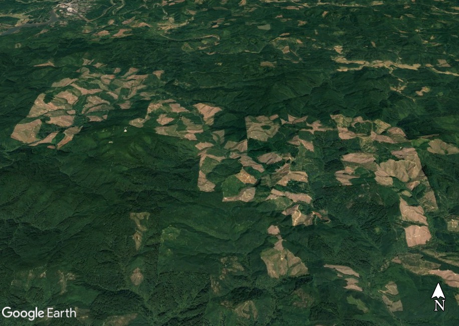
Siletz Gorge clear-cuts
The Siletz Gorge in Lincoln County is covered in clear-cut land.
Photo by Google Earth

Clear-cuts east of Seal Rock
A large patch of clear-cuts is visible east of Seal Rock, Oregon.
Photo by Google Earth

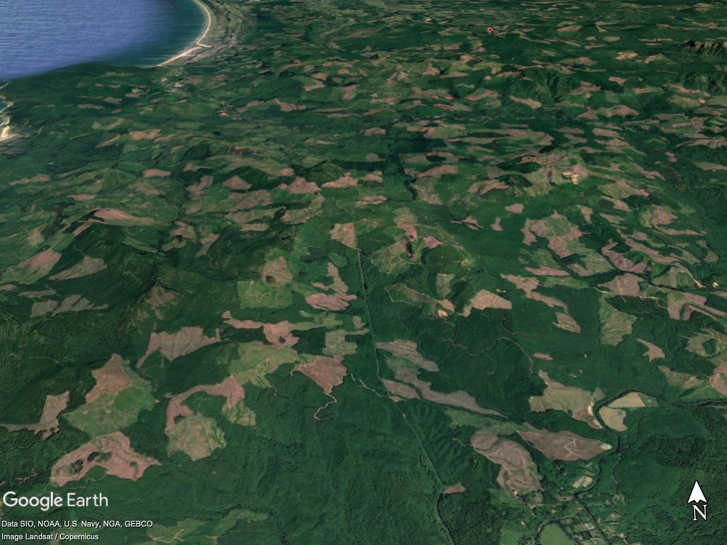
Clear-cuts east of Cannon Beach
Clear-cuts are shown east of Cannon Beach in Clatsop County, Oregon.
Photo by Google Earth

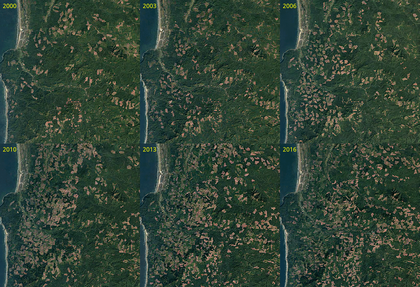
Southwest Clatsop County clear-cutting GIF
This images shows a time lapse of Southwest Clatsop County. Over 16 years, most of the landscape is clear-cut.
Image by Jason Gonzales/Oregon Wild via Google Earth

FURTHER READING:

• Is it time for a cultural shift in how we think about logging, forests?

• How today’s timber wars are playing out in Portland’s backyard

• The thinning debate: Does logging help or hurt fire mitigation?


Street Roots is an award-winning, nonprofit, weekly newspaper focusing on economic, environmental and social justice issues. Our newspaper is sold in Portland, Oregon, by people experiencing homelessness and/or extreme poverty as means of earning an income with dignity. Learn more about Street Roots

 
Tags: 
forestry
  • Print

More like this

  • Clear-cutting’s still rampant in Oregon, MAX train reminds us
  • Clear-cutting moves up to No. 1 emissions source in Oregon
  • Bipolar disorder with a bird’s-eye view
  • Cut and run dry: Do Oregon tax laws favor the timber industry?
  • In rural Oregon, trips to food banks are the new normal
▼
Open menu
▲
Close menu
  • © 2021 Street Roots. All rights reserved. To request permission to reuse content, email editor@streetroots.org.
  • Read Street Roots' commenting policy
  • Support Street Roots
  • Like what you're reading? Street Roots is made possible by readers like you! Your support fuels our in-depth reporting, and each week brings you original news you won't find anywhere else. Thank you for your support!

  • DONATE